Over Time, Even The Facts Change
On the road…again!
Afghanistan to Zambia
Chronicles of a Footloose Forester
By Dick Pellek
Re-Learning Geography
Learning the names of state capitals was a fundamental part of geography classes, and in grammar school, Geography was his favorite subject. Although some people believe that knowledge is power; others discount the importance of book learning if there are no practical applications of facts and figures that are learned in school. This brief chronicle concerns the application of knowledge about how even the facts change. What may be true at one time does not make it true for all time. In other words, facts may change.
The best example that comes to mind is the alteration of the facts regarding the documented elevation of notable mountains. The Footloose Forester believed that the height of Mt. Everest in Nepal was 29,028 feet--because that is what his grammar school geography book said. We now know mountains shrink as well as grow and since the Himalaya Range is growing higher with the passage of time, the documented height of Mt. Everest will be reportedly greater in modern publications than it was in old textbooks.
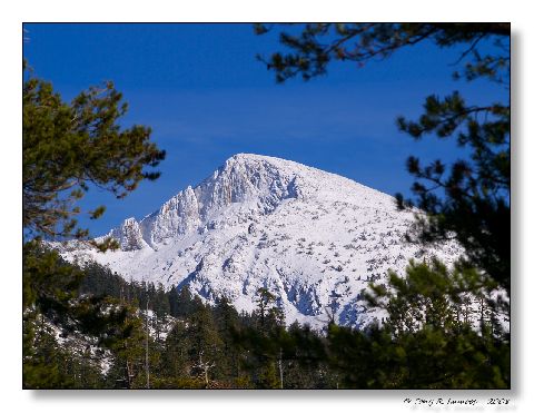
Another example is that of Pyramid Peak, in the Crystal Range of the Sierra Nevada Mountains of California. For many years, topographic maps showed the peak as 10,002 feet in elevation. When Footloose Forester reached the summit of Pyramid Peak as an adventurous young hiker, he believed he had passed a milestone by climbing a mountain over 10,000 feet tall. Modern surveying instruments now tell him that Pyramid Peak is no longer registered as 10,002 feet. The lastest reference he saw listed it as 9,987 feet. Quite a difference!

Pyramid Peak, Crystal Range of the Sierra Nevada Mountains
Other changes in geographic data abound. Perhaps the grandest discovery took place when calculations from satellite data confirmed that the famous crossroads in the American West where New Mexico, Arizona, Colorado and Utah meet--is actually in error by over two miles. Just recently in 2012, it was confirmed that the southern border of North Carolina was just far enough into South Carolina to affect 93 property owners who thought that they lived in South Carolina. The "fact" of their state residence persisted for 240 years, ever since the boundary was surveyed. Municipal and administrative problems have since arisen.
Of course, the names of some nations have changed as the colonial period of history becomes ever dimmer. No more Ceylon, no more Burma, or Cambodia; or Upper Volta. The former Gold Coast transitioned into the name Dahomey; then evolved into Togo. India is still India, but Bombay has been eclipsed by Mumbai, and Calcutta is now Kolkata. And it is now easier to get lost in the former Saigon after it became Ho Chi Minh Ville--because they also changed the names of scores of streets to honor communist revolutionary heroes.
About the author
Related Posts
Comments 2
You can't take a more spectacular picture!
I'm not sure the facts change, but the evidence certainly does change over time! Beautiful photo.


